 FREE UK tracked delivery
 Order by 12pm Mon-Fri for same day dispatch
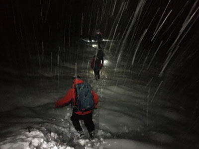
Night navigation
by Nigel Williams

Yes, there are some simple precautions we can take in our planning, a few skills we may not regularly use in the day time with good visibility. Other senses often kick in to compensate for the reduced vision. Having a good quality head torch, and ensuring you have some backup power for it, is essential.
Anxiety/Stress Behaviour
Being out in the dark is likely to go hand in hand with a level of anxiety about being late, causing distress to others, or becoming disorientated in the absence of visual landmarks.
Recent research into differentiating anxiety and stress suggests that when we are anxious there is a tendency to be risk averse, keep to the plan/path etc. This may be the case as darkness sets in. However, if anxiety builds into stress (a lack of phone signal perhaps) then there is a tendency towards risk taking, changing the plan, deciding a short cut across country will save time (it rarely does, and in my experience often makes matters worse). Managing anxiety/stress levels is part of the challenge, especially in a group, where there may be a range of different tolerance levels and opinions.
One of the challenges to our confidence of navigating in the dark is that we can end up being in that position due to navigational errors earlier in the day, and that can lurk at the back of our minds. To try to manage this it can be helpful to stop before it gets dark, have something to eat and drink, maybe make a phone call to let someone know you will be late, and study the map for all the clues that might help you navigate at night. Prepare for the task, ensure your compass is handy (and away from your phone), check your head torch and put it in a pocket ready for the darkness and ensure you know where your power bank or spare batteries are.
If you have digital mapping and GPS then this is clearly a useful addition for navigation. Check your location and battery state, consider using airplane mode to reduce usage.
People generally aim to walk on easy-to-follow paths, or other linear features, which can be followed in the dark with a head torch using basic map setting skills. If caught in darkness on a large expanse of open ground, then getting onto a linear feature is a high priority in order to make life very much easier.
When visibility has gone it is easy to become disorientated, as our ability to set a map using landmarks becomes limited. We become much more reliant on the compass for straight forward map setting, and route-choice decisions at junctions in the woods. Going cross-country, a compass is really an essential tool for maintaining accurate direction.
Pacing is something we don't often need in the daylight, but being able to measure distance accurately on the map, and transfer that information to the ground, becomes a key skill at night. Timing is another skill that can be used.
Using other senses
Another of the senses that often kicks in is hearing, and, in particular, noticing the sound of running water, which may help confirm our progress along a track. If we are really uncertain of our location, streams are linear features, so it is possible to check the rough direction that the water is flowing with the compass. Sometimes this can be a clear indication of our position if it is, say, the only stream running north/south in the area. Or it may at least eliminate a couple of streams we cannot be on and narrow down our likely position.
Feeling the contours is often another heightened sense, whether that is noticing underfoot the path changing angle or recognising what the path is doing by observing the ground either side of it. A path I use regularly descends gently for around 3 kilometres but has one place where it runs flat for about 300 metres; easy to identify on the map as the path parallels the contour line for a few millimetres. Therefore, going across country with a compass bearing we can usually feel the slope in our ankles and knees. If we can see from the map that we expect to be crossing the contours roughly diagonally we can envisage how that should feel, and can certainly tell should we find ourselves descending straight down. Changes in the slope aspect and angle can provide us with location or progress information.
The more we can multitask in our heads, with feeling the ground, following the compass, and timing or pacing, the less likely we are to become disorientated, as each piece of information or skill backs up the others.

Head torches
These do seem to be getting ever more powerful and expensive. However, something around 200+ lumens, and preferably rechargeable from a phone power bank, can be purchased for under £20. A power bank should be a standard item in the outdoors when carrying a mobile phone, but don't be tempted to think the phone torch will light your way, although it can help see the map better. Hands free light, with a good beam length, is essential, especially if you use walking poles, which are particularly useful at night.
Although a powerful torch will light up more of the scene around you, in mist the light is just reflected back at you, and, no matter how powerful the beam is, it won't really help.
A useful tip when navigating at night, particularly in open country, is to turn off all torches, give a few minutes for your eyes to adjust, and then squat down and look around you at the skyline; it can often reveal information the torch beam cannot reach.
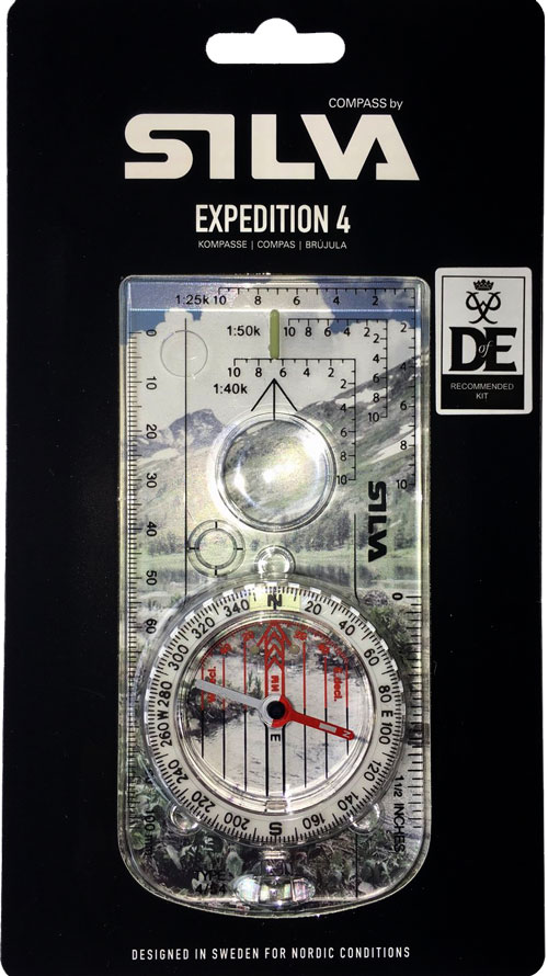
- If you are in need of a compass then we stock a great range of items and other useful navigation equipment, suitable for all levels of navigation.
- For the perfect lanyard to go with your compass, the HARVEY Map - Measure - Go! scale bar laces double up to make measuring distance easy! Available in two scales, 1:25,000 scale markings (red) and 1:40,000 scale markings (yellow).
Return to the Navigation Blog


