FREE UK tracked delivery
 Order by 12pm Mon-Fri for same day dispatch
Using a compass, a beginner's guide
by Nigel Williams
Research suggests that over 70% of walkers do not wish to leave a footpath. Today almost every viewpoint or objective has a footpath leading to it. So, for the beginner navigator, walker or cyclist, navigation is usually simple decision-making at a junction, requiring map "setting" or "orientating", which can be done without a compass by aligning obvious land marks to their symbols on the map.
It is commonly said that finding the right way out of the car park is one of the bigger navigation challenges most people face. Being in a forest with little to view other than trees and paths can also be disorientating, so map setting is where the most common use of a compass comes in.
Beginner compass work is a simple static process, usually when standing at a path junction. The compass needle enables us to orientate the map without identifiable landmarks and helps us confirm a route decision. There is no requirement for a rotating numbered dial to record a bearing, or to walk using the compass to maintain an accurate direction. Those techniques are required for going across country often in poor visibility, which requires confidence and skills beyond the beginner.
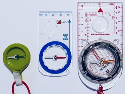
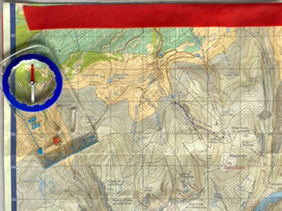
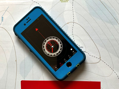
1. Simply drop the compass on the map and turn the map until the red end of the needle points straight up the map towards the north edge of the map (where the map title is) it should align with the north / south grid lines. A mobile phone compass can also be used if calibrated; check it against a compass needle, but keep the devices well apart.
2. To look in different directions up and down the path, for instance, we need to keep the map in that orientation and move our bodies around the map whilst facing it. We have to move our hands around the map but not turn the map. If this seems awkward try putting the set map on the ground and walking around it sideways continually facing it. Whichever way the navigator looks over and beyond the map the main landmarks should match the relationship between their symbols on the map.
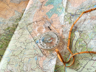
There is a slightly more advanced map setting process to confirm or help make a decision at a junction. In effect, it is a simple or quick bearing and just uses the needle and base plate.
1. Before setting the map, put the edge of the baseplate along the intended path on the map, ensuring the direction of travel arrow is the right way around. It helps to have your body behind the base plate so as to look naturally down it.
2. Then, holding the map and compass firmly and locked in place with your body, waddle round like a penguin until the red end of the needle points to the top of the map. The compass base plate will then be pointing straight down the path you want on the ground.
The solid red needle points to the north edge of the map and the edge of the phone is along the intended path and can be aligned to it on the ground. (In some ways this helps understanding of the process as one cannot fiddle with the dial!).
This process is helpful if we have lost track of our journey and are unsure if a path junction we are at is the correct turning. The process can be repeated on different paths on the map to see which one best fits, a process of elimination to indicate our position; so it is also a useful relocation skill.
This relocation process can be speeded up. However, it involves a bit more multitasking.
1. Point the compass baseplate accurately down the unknown path on the ground, holding it steady in one hand; hold the map in the other hand and orientate to align with the needle.
2. Slide the map under the compass focus on the edge of the baseplate and along the path one is on, whilst still keeping the compass pointing down the path on the ground. The base plate edge should eventually align with a path on the map and pinpoint your position. Other linear features such as streams, fences and wood edges can also be used for relocation).
Sometimes there may be more than one possibility so you will need to identify an obvious difference; e.g. does one path bend to the left and the other to right? You may have to "move to prove" - walk down the path a little way to determine which one it is.
The numbered dial and lines in the capsule are irrelevant to the beginner; numbers are only for communicating a compass direction to someone else. Magnetic variation is irrelevant in the UK as it is currently less than the accuracy tolerance of a compass and changes by about 1 degree every 6 years.
Interestingly, orienteers, who are generally the best on-foot navigators in the world, use a compass without lines and numbers, and a dial that does not rotate. Unfortunately, our traditional teaching of the compass for beginners originated from the military, before maps for recreation were generally available and affordable for the public. Great accuracy for heavy weapons and cross country travel at night was often required, which has led to the over-teaching of complex processes for recreation. Orienteering also began in the military, but, because it also involved running, it became a niche sport, and the general recreational public are not aware of how they have simplified the use of the compass to speed up the process and create a successful and simple teaching methodology.
- If you are in need of a compass then we stock a great range of items and other useful navigation equipment, suitable for all levels of navigation.
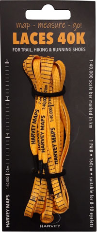
- For the perfect lanyard to go with your compass, the HARVEY Map - Measure - Go! scale bar laces double up to make measuring distance easy! Available in two scales, 1:25,000 scale markings (red) and 1:40,000 scale markings (yellow).
Return to the Navigation Blog