 FREE UK tracked delivery
 Order by 12pm Mon-Fri for same day dispatch
Why I teach with an orienteering map
by Nigel Williams
Confidence is a major part of navigation because it involves observation, deduction and decision making. When asked the reason for attending an introductory navigation course I estimate that at least 3/4 of people mention the word "confidence".
Across the outdoor activity, sector instructors use a range of controlled training environments such as indoor climbing walls and bike skills parks to teach their clients basic skills prior to using them in a real world context. It adds a level of safety and due diligence in assessing capabilities, and there is usually a wide range of difficulty level and teaching progression options. It also helps reduce the consequences of a novice error, minimizes anxiety about remoteness, fitness and offers an option to opt out if they wish. But fundamentally it helps people quickly develop confidence in the skills required to participate in, and enjoy the activity in its wilderness context.
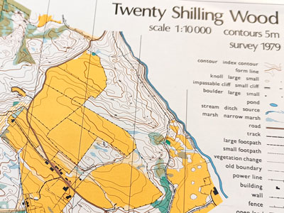
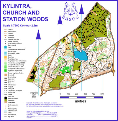
Orienteering maps use a range of scales around 1:10,000 depending on the size of the area mapped. That is 10 centimetres for a kilometre, or 1 centimetre represents 100m on the ground, so they can add in all the detail such as boulders, lone trees, ditches etc. that the novice sees adjacent to the path. There is then lots to keep them engaged, they are able to keep track of their journey, and it builds confidence.
The reasons for dismissing the benefits of using an orienteering map are that people struggle with the scales, and the symbols are different to real maps. The colours are distracting, yet many of us have got used to using Harvey maps. However, listening carefully to instructors using these excuses makes me think they are more reflective of the instructor's opinion as opposed to those of their novice clients. (50 years ago many climbers were equally disparaging about indoor climbing walls and coloured protruding handholds, yet today most view an indoor wall as a key teaching tool for novices).
The logical map progression for novices would be to start with the orienteering map scale. Once confident with the basic skills they can move onto the 1:25,000 as they start to look farther afield and can cope with less detailed information. Eventually they can progress to the 1:50,000 with even less information and requiring a good appreciation of what features might and might not be marked.
Another good feature of an orienteering map is that it doesn't have any writing on the map so helps train the brain to rotate symbols. Most writing on a map is only useful if one is stood at a sign post. Whilst rivers are named on a map there is no signage beside them on the ground! As Professor Kate Jeffery, professor of behavioural neuroscience said, "The brain's navigation system did not evolve to use verbal signs, and does so only with difficulty".
Historically, the 1:50,000 map was the most easily available map scale and was good value for money as one got around 4 times more area on a sheet the same size as a 1:25,000. Also, this is the scale many people first come across at school in geography and the exams. As discussed in other blogs, geography lessons focus on static map reading and numeracy rather than on the move navigation, observation, deduction and decision making.
In the last 10-15 years orienteering maps have become much more available and are now in my opinion the single most useful navigation teaching tool. I'm not suggesting entering orienteering events, there is a big difference between that and using the map to teach or practice navigation skills.
British and Scottish Orienteering now have hundreds of downloadable maps of permanent orienteering courses around the UK.
Return to the Navigation Blog


