 FREE UK tracked delivery
 Order by 12pm Mon-Fri for same day dispatch
5 staff favourites from Loch Lomond & The Trossachs
At HARVEY Maps we are privileged to have Loch Lomond & the Trossachs National Park on our doorstep. We can see it from our office! Post work hikes and weekend adventures, it is here where we can be found. We asked the office to tell us about their favourite hill on our Loch Lomond & the Trossachs 1:25,000 scale Superwalker map. This is what they said.
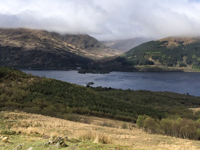
Our production director Chris leads us up one of the most popular Munros, Ben Lomond. Being the most southerly Munro and less than an hour away from Glasgow, Ben Lomond is not the hill to tackle if you want to avoid the crowds. However, the Ptarmigan route offers a more rugged, rewarding and lesser-used alternative to the main tourist path.
Starting from Rowardennan, the trail ascends steeply past patchy woodland then breaks out onto the open moor. The path follows the Ptarmigan Ridge - remember to take plenty of breaks to look behind you as the views to the west are stunning, across Loch Lomond to the Arrochar Alps, with the distinctive shape of The Cobbler is an easy peak to spot. As height is gained, the ridge narrows and becomes rockier, and the final climb to the summit is steep but exhilarating, with panoramic views at the top. The descent via the main path is gentler, offering a well-earned cool-down, an excellent southerly view of Loch Lomond's islands, and that sense of satisfaction you get when you are leisurely walking down the hill while everybody you pass is sweating their way up!
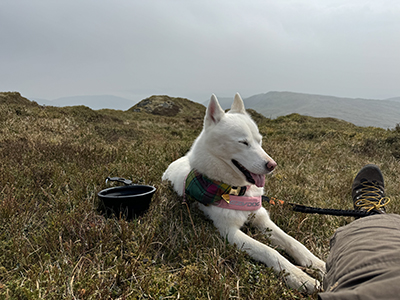
Looking for a quieter hill? (Beinn) Each to their own. Cameron and his dog Spirit guide us up this surprising Corbett. A quieter hill than the more popular Bens in the area, but still easily accessible, Beinn Each was the first Corbett I climbed with my dog, Spirit. We walked from the A84 up through the trees to the track along Glen Ample, and once it had forded a stream we turned up right for the steeper ascent to begin.
The path took us to the 813m summit, after which the map really came into its own; instead of simply backtracking, we continued along the south-east ridge to Meall na Caora, then descended cross-country to return to the Glen Ample track. That's the great benefit of good quality mapping: the map gives you the navigational confidence to venture off path and create your own routes.
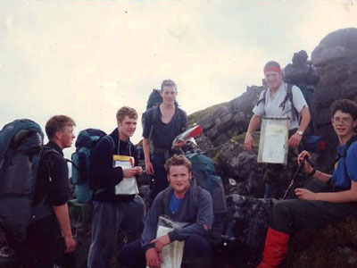
Our CEO Adam (far left) reflects on a Duke of Edinburgh trip to the summit of Ben Vorlich, when the Trossachs were once much further away. It is now nearly 30 years since I climbed Ben Vorlich with my Duke of Edinburgh Gold group back in the mid-90s, and unfortunately, I must confess I have not been back to the summit since. Having made the long journey north from the Cotswolds, I was very excited at the prospect of being in Scotland and wild camping for a few nights with my mates.
I recall our route started from the shores of Loch Earn and we began the long and steady climb southwards, trudging our way in single file to the top of Ben Vorlich and then enjoying panoramic views from the 985m summit. Compared to the Cotswolds, to the eyes of a 17-year-old the Loch Lomond & the Trossachs National Park was a beautifully wild and new frontier!
Ben Ledi next, a prominent hill in the skyline whilst we drive into work. One sunny summer evening not long after I had started working at Harvey Maps myself and some colleagues decided to hike up Ben Ledi. We started our assent at the car park at the foot of the Eastern side of the Corbett deciding to follow the well-established footpath to the summit. We were joined on our journey fairly early on by a vole which happily walked along side us for around 20 minutes only leaving us when we reached a drainage gully which it was unable to cross.
After a couple of false summits, we eventually arrived at the trig point marking the summit and were treated to spectacular views of Loch Lubnaig and Loch Venacher, Stuc a' Chroin to the North East and as far as the Cobbler and Arrochar Alps to the South West. We decided to descend on a rather more off-piste route making very good use of the Loch Lomond & The Trossachs Superwalker Map to navigate our way down the North slope arriving at the Southern tip of Loch Lubnaig. Not long after we started our descent the skies quickly clouded over and rain began to fall, the end of a typical Scottish summers evening.
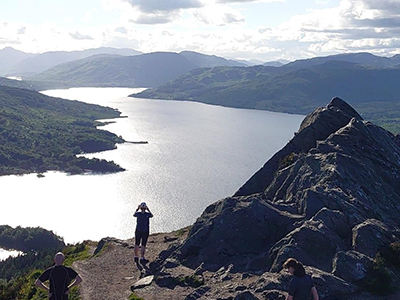
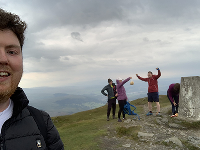
A sprinkling of déjà vu on top of a small but mighty mountain. The smallest hill on this list but definitely not one to skip over! This is my most ascended hill and for good reason, the view-to-effort ratio is like no other that I've climbed. When I have friends visiting, this where I take them.
My first ascent was with a few colleagues on a post-work hike a few weeks into moving up to Scotland to work at HARVEY Maps. The hike is relatively short in both distance and ascent, though in places it is rather steep! We climb and chat, getting to know my colleagues in a more informal setting. Our efforts were soon richly rewarded with a view more breathtaking than I was expecting. The last time I had been so taken aback by a view was when 8-year-old Luke first caught glimpse of the lush green and wide expanse of the Craven Cottage pitch. Spellbinding. The panoramic view is truly BenA'anas and yet I still had a strange sense of déjà vu. Somewhere, I'd seen this view before. A few group photos later it clicked. This view used to be my desktop background! The images our machines supply as backgrounds always looks so serene and perfect it's almost strange to think they are real places, let alone now on my doorstep! That's why I keep coming back.
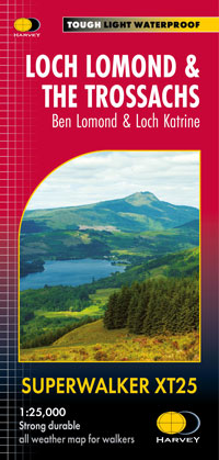
Unlock all these hills including even more Munros, Corbetts & Grahams with our Loch Lomond and the Trossachs Superwalker map. Not fancying a hill? This map opens up more lochs to adventure than a skeleton key. You have the entirety of the Great Trossachs Path and large swathes of the Queen Elizabeth Forest Park to enjoy.
Return to the News & Features Blog


