 FREE UK tracked delivery
 Order by 12pm Mon-Fri for same day dispatch
Fastpacking the Affric Kintail Way
by Jen Scotney
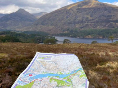
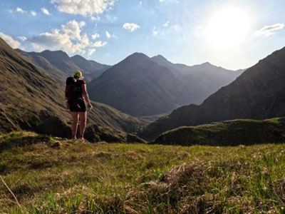
I had ordered the HARVEY Maps Affric Kintail Way long-distance trail map at the start of the year. The trail, only 44 miles (although I made it closer to 48), had pulled me in with pictures of islands on lochs appearing through old Caledonian pine forests and a wide, sweeping glen. I was about to find out it was so much more than that.
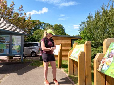
For some of my adventures, I will pore over the maps for hours and plan every detail. As this weekend was making fairly last-minute use of the uncharacteristically sunny spell we are having in Scotland, I was going into this without much planning. Early on Friday morning, I drove from my house in the Southern Highlands, through Glen Coe and beyond to park at the Morvich National Trust car park.
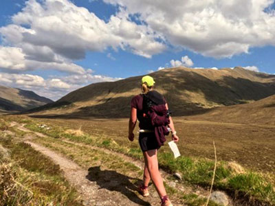
The bus had been 30 minutes late, and now the thought of self-stranding myself so many miles from my van wasn't feeling like such a great idea. I hadn't attempted anything this long since having two knee replacements, and I was only carrying enough food for a maximum of 48 hours at most. I had decided to pack light and travel fast because I enjoy moving without a heavy pack, and it was also a test to see if my recent local Munro bagging has helped get me somewhere towards fitness. Adjusting to a life without running ultramarathons and learning to live with my new knees has taken years and many tears. Not quite enough to fill Loch Ness I was now travelling beside, but certainly a few.
Our bus pulled into Drumnadrochit, and no sooner had I asked the woman next to me if it would stop automatically, she reached up and pressed the big red stop button above. A loud alarm screamed, and the bus quickly pulled over at the bus stop. 'I'm not really sure if that is for that use or if it's for emergencies, ' she then told me with a shrug. I alighted the bus and took out my first of four cut-up map sections to see how far I was from the beginning. I walked a third of a mile down the road towards the marked start, tempted by seeing the route heading off to the left out of the houses, but knowing that I also wanted to do things properly, and to start at the start. It felt odd that only a couple of hours before I had started at, well, the end. But there was a big adventure in the middle to come.
I started my watch and left the car park after a look at the information board and a few photos. I think I had been in this spot almost exactly nine years ago, heading into the Loch Ness gift shop to my left, having no idea I would be here as a Scottish resident all those years later, with surgery scars across my bare knees and many stories to tell of new careers.
I retraced the route I had come from the bus and then started the ascent into the woods, grateful for some shade in the early afternoon heat. The path is marked by regular markers, with black mountains and the sun rising above on a white background. They became a cheery sight. I had studied the first section of the route a little on the bus journey; mostly forest tracks winding west to Cannich with the odd road crossing. A lot of the forest sections had been felled, which made for a more varied and more view-friendly route than the map had suggested it would be.
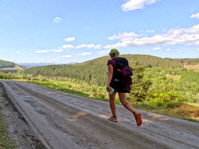
As the miles rolled on, the anticipation I had felt for the promised glens and views was turning, dare I say, to slight frustration. The mountains I could sometimes get tantalising glimpses of never seemed to get closer. I came down into Cannich feeling a little deflated with the route. It had been pretty woods, but nothing remote or dramatic. Not even the large packet of salt and vinegar crisps from the local shop could cheer me up.
Cannich to Glen Affric Car Park
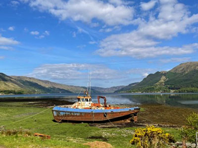
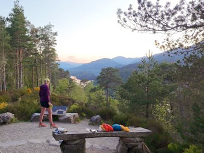
I came down the forestry track into the Dog Falls car park. Looking at the map, I decided I would carry on through and camp down by the loch, less than 2 miles further. I was met with two small tents in the car park. A woman was cleaning her teeth outside the toilet block. She told me they were on the TGO Challenge, planning their own route across Scotland for two weeks and a couple of days in. She said they had walked a further five miles to this spot from the other direction to me, due to a lack of water. I decided to fill up my bottles and take an extra 1.5 litres here and carry the extra weight, in case I camped before the loch. With it nearly 8 pm now, it would mean I didn't need to filter or boil water. I climbed the hill after the beautiful falls, energised by the enthusiasm the woman had for their trip and camp and the conversation we had shared. At the top of the hill was a detour up some wooden steps to the viewpoint, and I wasn't going to miss this, despite wanting to set up camp as soon as I could. I was so glad I didn't skip the extra 10 metres as the view was breathtaking. The old pines parted to show the rosy sunset over the lochs and glens stretched out before me. Islands floated on the loch. I stood just soaking it all in for a minute, mentally deleting the complaint to Trading Standards I had been writing for the last few hours about the lack of views on this route. I looked around and realised my little tent would fit in the space at the viewpoint, and without a breath of wind, and with a rock or two, it wouldn't matter that I couldn't put a tent peg in the hard ground.
I didn't rush over coffee or breakfast; these peaceful moments are my favourite part of any of my camps. Selfishly soaking in the fact that all I had to do today was follow my map. No responsibilities, no disturbances, and my phone is set to aeroplane mode. It was back to more forestry tracks to start, but they did have the loch and closer mountain views this time. At the end of Loch Beinn a' Mheadhoin, I first heard and then saw some waterfalls. I took a detour towards the Glen Affric car park to admire the river; also grateful it was the last glimpse of a public road and hopefully the start of a more remote section.
Turning away from the bridge back to the trail meant the Caledonian forest thinned out a bit, giving views over to the beautiful estate house, and statuesque mountains beyond, with cuckoos calling all along the route.
The trail seemed busier than ever here despite the more remote landscape. I was passing walkers with small packs, presumably doing a circular walk around Loch Affric, along with larger, packed singles and couples coming both ways. It wasn't the Scotland I was used to, but I guess part of being on such a popular trail. I spoke to some in the next few miles; the polite school children who had been staying at the Glen Affric Hostel, and some more TGO walkers, one of who reliably informed me the unseasonably dry weather meant the midges weren't out yet.
After I passed the turning for the loop round the loch, the trail quietened. I was glad, I love my solitude on these adventures, and meeting so many walkers had made me start to question if I should have just headed on my own route for the weekend from Kintail rather than this long-distance path.
He had been telling me about the journey they make across the seas back from the southern hemisphere. And as I listened to them now, I thought about how they had been guided back here, with an innate knowing of where they belong. I wondered if us as humans had often become detached from that knowing. Losing it in a busy, concrete-covered world. I peeled myself off the rock and carried on the flattening glen. I was reminded of the cuckoo's journey not much further on, though, as the ruined shells of homes from the Highland Clearances were at my feet. Feeling the sadness of people ripped from where they belong.
Glen Affric Hostel - Kintail
The next stage of the route was a narrowing of the path, funnelling me toward what seemed an inaccessible route between the pointed and greener rocky mountains ahead. The heather and Caledonian pines seemed long behind me now.
I met a woman sitting on a rock, who was early for her hostel stay, and we chatted about her upcoming trip on the Hebridean Way, which she was practising for. We mostly talked about the kit, as she saw my little pack, which was about a third of her large rucksack. When she asked when I had started, I heard myself say I 'only' did about 22 miles yesterday, and was on about 18 today, noticing how great my legs were feeling still. Maybe I was fitter than I had been worried about on the bus journey full of doubts. The hard tracks had left my feet feeling a little tender, but nothing but a few hot spots.
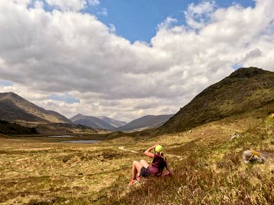
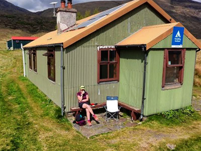
The next stop was the Camban Bothy, where beds had already been claimed, and a group sat out in the sun. A small group had come from Shropshire and had never had weather like this in Scotland before. We shared routes and wishes, and I headed on, leaving the wider rough track and now on some singletrack path. The views were stunning, as I was winding along the side of the slopes, with the burn below tumbling into a growing gorge. I suddenly realised the water was flowing in the same direction as me. I must have crossed the watershed, and we were both making our way down to the west coast and the sea loch below. It made me quite sad as I looked at the map and realised I only had less than 7 miles to go. I wasn't ready to leave these towering mountains yet, as I twisted deeper and deeper into them. Suddenly, the path dropped down steeply before me, and I decided to take another break and prolong the adventure a little more. I got out my stove to cook some curry. At 5.30 pm I wasn't rushing to put my tent up, though I was tempted with another night out on the trail. I lingered for an hour and a half, eating and drinking some more tea. But I was now at the head of the bealach, and gusts of wind would swirl up the twisted path. They made me decide that I would sleep down in the van, out of any wind, and which was less than two hours away, even if I slowed to a walk.
I carried on. Having not looked at the route ahead, the path curving round, revealing a dramatic waterfall beneath where I had been cooking, was a complete surprise to me. I stood there, stopped in my tracks again, with the beauty of it all. I met some hardy bike packers ascending, attempting the HT500, looking more than beaten on their climb up. There were still a few hours of daylight, but they said they wanted to get to Tomich. I tried to think when I had last seen a sign for that, it seemed a while ago, but the last few days were now merging into one hazy one. I wished them luck and secretly hoped there was space and a welcome at the bothy for them.
The last descent and then the track down to the finish was just with me and the lambs, as the sun set over the hills. I looked back as the full moon rose over Meall a' Charra. Part of me wished I had stayed up there another night, but I was also looking forward to the snacks in my van. I finished unceremoniously in the car park, watched by a young stag. It felt like I had crossed the whole of Scotland in 30-something hours. A beautiful journey through such different landscapes, each revealing itself to me, while I just had to put one foot in front of the other. And one new knee in front of the other. The knees were happy enough. In fact, they hurt a lot more sitting at my desk for 8 hours on the days I have to work. But we knew that, didn't we? We are designed to move and connect with others. As Paul Coelho said, 'If you think adventure is dangerous, try routine; it's lethal.'
May I, my knees, and my maps have many more adventures to come.
Jen Scotney is a HARVEY Maps Ambassador, living in the Scottish Highlands. She is a mountain leader, podcast host, and author of 'Running Through the Dark'.
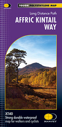
If Jen has inspired you to tackle the Affric Kintail Way, then this is the map for you - HARVEY Maps Affric Kintail Way Trail Map.
Return to the News & Features Blog


