FREE UK tracked delivery
 Order by 12pm Mon-Fri for same day dispatch
April 2021 - Route planning
by Nigel Williams
Naismith's formula uses estimated speed, distance and height gain to work out how long a walk is likely to take. I'm careful to refer to it as a formula not a rule and also consider it as a whole journey or day estimate. We often set off fast at the start of the day but are slower by the end.
The steepness of the route, rucksack weight and weather all influence our individual speed. Try keeping the wind on your back over the high ground which may mean doing a route in the opposite direction to the guide book description. MWIS (Mountain Weather Information Service) forecasts put the wind speed and direction first as it can have a significant effect on planning, far more so than precipitation or temperature.
The group size will also impact route planning. I add 30 minutes per person when leading groups on a scrambly ridge walk to allow for the group being stationary while each individual negotiates an awkward step. On the Speyside way, for instance, between Nethy Bridge and Grantown on Spey, there are 17 gates and stiles to be negotiated in 6 km!
Planning also has a seasonal element - with shorter days and winter conditions, we carry more and although we want to avoid being out in the dark, a head torch should always be packed. In deep snow, moving uphill, a speed of 2km per hour is quite likely.
So, back to Naismith. The often quoted speed is 4km per hour (it's not a target!) with 1 minute added for every contour line crossed going uphill (assuming a 10m interval) and downhill treated as being on the flat. A tip is to just count the thicker index contours - crossing one of these will add 5 minutes, though this is often generous for regular hill walkers on a good path. With HARVEY maps using a 15m interval and 75m for index contours I tend to use the same calculation but one could calculate based on 1.5 minutes per contour.
With DofE groups, novice hill walkers or a larger group I tend to plan for 3km per hour and over the course of a day, including rests and stops to look at things, it tends to work out reasonably accurately, but one can simply add chunks of time for stops which builds in some leeway if there is a specific time to be back by.
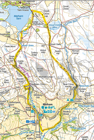
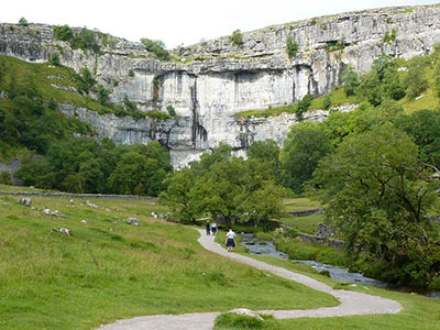
A good example to illustrate this is a circular walk in the Yorkshire Dales National Park from the village of Malham. This walk starts at a height of 200m and follows the path (The Pennine Way) north to Malham Cove and Malham Tarn. The route then heads east over Great Close Hill (at 465m it is the high point of the walk) before heading south on the path to Goredale Scar with a scramble descent and finally following the Goredale Beck path back to Malham. In total, the walk is approximately 12km and includes 265 metres of ascent.
Using Naismith's formula, this distance suggests the walk will take 3 - 4 hours. The metres of ascent will add an additional 30 minutes. With a group, I might add another 30 minutes to descend Goredale Scar. If it is a fine day add an hour for photos and admiring the incredible limestone scenery. So, all in all, the whole walk is expected to take 5 to 6 hours depending on my knowledge of the group.
When a path has short zigzags up a long steep hill it is easier to ignore the distance and estimate around 400m of ascent per hour. Fitness though can significantly affect this.
Using the free OS Locate app on a phone which has an altimeter, it is easy to do a height gained/time calculation. Similarly, there are other GPS based apps and digital mapping that can record your route and return average speeds and other useful statistics. That recorded information is really helpful, informing realistic planning in the future.
Return to the Navigation Blog