 FREE UK tracked delivery
 Order by 12pm Mon-Fri for same day dispatch
December 2021 - Navigation and looking ahead
by Nigel Williams
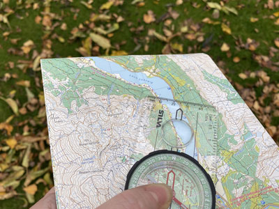
Maps were largely created to support military campaigns and trade, however, they were not available for the general public until travel and recreation in the Victorian era began to flourish. Well into the 1900s, mapmaking was still being carried out with basic tools and triangulation. Over 20 million maps had to be printed for the First World War and by the mid-1930s, accurate 1 inch to the mile maps of all of the UK with contours and a grid system were being mass produced and available to the general public for recreation.
Thirty years on, the first satellite was put into space by the former USSR in 1957; a few months later the USA launched theirs. The possibility of a global positioning system was put forward in the USA in the early 1970s and in 1993 a full set of 24 satellites became operational and free for public use. The system was then available on mobile phones in 1999. Since then, Russia, China and Europe have global systems and a number of other countries are operating national systems.
But is satellite GPS the solution? Devices capable of jamming and spoofing have become easily available and GPS interference is now near the top of many countries' geo political strategic planning. On the UK's government risk register, GPS interference is in the same bracket as a pandemic. In addition, the fastest growing segment of the Positioning, Navigation and Timing (PNT) sector is associated with the anti-jamming market.
In November this year Russia used a missile to blow up a redundant satellite which demonstrated the capability but also highlighted the potential to damage other satellites with the resulting space debris.
It seems extraordinary that in the space of 30 years we have developed a hugely beneficial technology that impacts almost every aspect of our lives and then we create the means to destroy it. In terms of navigation, in that short period of time it is now evident that habitual use of a GPS is detrimental to the development of those neurologic pathways in the hippocampus that have supported our ability to navigate for so long.
However, it is not all doom and gloom: there are a surprising number of other land-based PNT systems already integrated with GPS and able to step in if the Global Navigation Satellite Systems (GNSS) is compromised.
Two possible land-based GPS developments which could be jamming-proof, as they are not reliant on satellites, are in development. They involve cosmic ray muons and quantum science neither of which I have any understanding of, however, they may be the next generation of PNT devices.
A positioning receiver detector has been developed to work with sub atomic muons linked with Earth's magnetic field. Muons are a natural source of radiation, cover the entire Earth's surface and pass through all matter - water, rock, etc. - at the speed of light.
Another possibility is what has been dubbed the "titanium avocado", it is small titanium and sapphire sphere the size of an avocado and weighs about a pound. It employs quantum sensors and miniature lasers which shine into clouds of rubidium gas in a vacuum and enable measurements of time, acceleration and rotation. Miniaturisation will be key to real world use for these devices. Both devices are expected to work indoors, underwater and at high latitudes north of the Arctic Circle where GPS coverage is less reliable.
Other navigation news stories that caught my attention are the development of vibrating shoe insoles with a motion-sensor electronic compass for people with visual impairment (not blindness) which link to a mobile phone route planning app. Once the route is plotted with GPS data the user receives instructions via vibration in either shoe to turn or both shoes to stop. It means that the wearer can still use other environmental cues as this is not based on sound.
Italy is starting to roll out a GPS based system for managing its entire train network, capable of controlling train speeds and distances from other trains on the line and at junctions and stations. It must be rather easier than self-drive cars which are not on a fixed track and carry out all sorts of manouevers on busy roads.
It has been a big year for the development of tools and information to measure animal navigation, migrations and sensory capabilities. MagGeo is a new world collaborative wildlife research arrangement which will share information and tools that will accelerate our understanding of wildlife geomagnetic navigation along with their use of the stars, sun, wind, smell, and visual land marks. It should help predict swarms, protect critical spawning grounds and place protection measures along migratory routes.
All these topics are examples of GPS dependant developments and the application of GPS navigation. But here is one that isn't.
Huge hospitals are a daunting place with so many floors, wards, theatres, consulting rooms etc., the vast majority of which you would not want to accidently walk into. GPS navigation indoors doesn't really work but a couple of big UK hospitals are now using a phone app with a detailed map of the hospital. Navigation is done via wifi and bluetooth sensors throughout the hospital to help people move around between floors and departments with real time directions both spoken and visual with a 1-2 m accuracy. It helps reduce anxiety of visitors and patients and reduces staff time spent trying to direct people around the building thus saving resources and may be a life or two.
Despite detaching ourselves from Europe, the UK is involved across the research and development of every one of these topics and many more which I am sure we will learn about in 2022.
Return to the Navigation Blog


