 FREE UK tracked delivery
 Order by 12pm Mon-Fri for same day dispatch
Digital mapping insights
Outdooractive
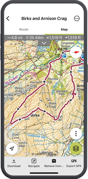
HARVEY Maps on Outdooractive combines trusted hill mapping with practical digital tools for planning and navigation in the outdoors. Walkers, hikers, and mountain explorers can access familiar HARVEY Maps on their computer, tablet, or phone, making it easier to prepare routes at home and navigate confidently on the hill.
HARVEY Maps' British Mountain Maps and Superwalker Maps are available digitally through Outdooractive with a Pro+ subscription, covering many of the UK and Ireland's most popular mountain and upland areas. Designed specifically for outdoor use, HARVEY Maps are valued for their clear, uncluttered detail and easy readability in challenging terrain. Getting started is simple:
1. Open Outdooractive on your computer, tablet, or phone
2. Search for the area you want to explore
3. Select HARVEY Maps as the map layer where available
4. Plot your preferred route and review distance, ascent, and estimated timings
5. Download your maps and routes for offline use before heading out
Offline access is especially valuable in remote areas where mobile coverage can be unreliable, while GPS positioning helps you keep track of your location on the map. Outdooractive Pro+ also includes additional tools to support your adventures, including 3D Flyover route previews, BuddyBeacon live location sharing, and Skyline peak identification.
Together, HARVEY Maps and Outdooractive offer a reliable combination of clear mapping and digital navigation tools, helping you plan more easily, navigate more confidently, and enjoy more time outdoors.
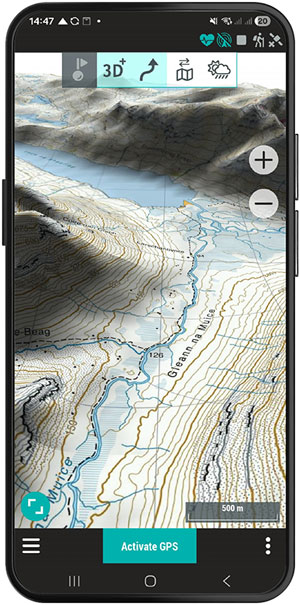
For hikers, mountain bikers and cycle tourers across the UK who demand complete control and precision when navigating in the outdoors, the TwoNav app has become one of the most comprehensive and reliable tools available. Designed for users who prioritise detailed mapping and advanced route planning, TwoNav allows you to work with highly accurate topographic maps even without mobile coverage - an essential advantage in remote areas such as the Scottish Highlands, Snowdonia or the Lake District.
Following recent changes in the digital outdoor mapping market, including Avenza's withdrawal as a key reference platform for many British users, TwoNav now stands out as the only platform where HARVEY Maps customers can continue purchasing digital maps individually, rather than being restricted to subscription-only models. This is particularly valuable for outdoor enthusiasts who only require specific maps for a single expedition, multi-day tour or planned route.
The TwoNav map store already offers extensive HARVEY coverage, including the acclaimed Superwalker and British Mountain Maps series, both highly regarded for their clarity and accuracy in mountainous terrain. In the coming days, the long-awaited HARVEY Trail Maps series will also be launched on the platform, making it even easier to explore iconic UK routes such as the West Highland Way, Pennine Way and South Downs Way.
Getting started with HARVEY Maps on TwoNav is straightforward. Simply open the TwoNav app on your smartphone, access the integrated map store, search for your chosen area or route and download the corresponding HARVEY map. Once installed, you can immediately begin navigation, follow GPX tracks and view your real-time position on high-quality topographic mapping. The app also includes 2D and 3D map views, alongside multiple configurable data fields that provide greater control and safety while navigating.
The experience is further enhanced by the complete TwoNav ecosystem, including synchronisation with Land for advanced route planning on desktop, compatibility with dedicated GPS devices and safety-focused tools such as route deviation alarms, track recording and advanced offline navigation. Altogether, this makes TwoNav an especially powerful solution for outdoor users who expect precision, reliability and independence on every adventure.
Return to the News & Features Blog


