 FREE UK tracked delivery
 Order by 12pm Mon-Fri for same day dispatch
January 2022 - Maps and the Mountain Leader award
by Lewis Taylor, Cartographer, HARVEY Maps
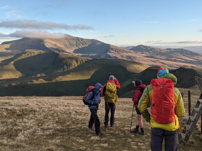
I chose to do the training in Snowdonia, a relatively unfamiliar area for me, in order to challenge myself as much as possible. The course consisted of a week's training with Phil George, based in Llanberis. I hoped that the Mountain Leader training and assessment would consolidate my existing skills, and add new ones, to allow me to better contribute to the survey team in my current role as cartographer with HARVEY Maps. As we typically create maps of challenging and mountainous areas, leading the survey team is a huge responsibility.
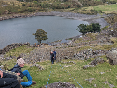
The training took place over six days, during which we studied navigation, leadership skills, mountain weather, steep ground hazards and ecology. Map reading is obviously a large part of being able to navigate accurately, and being a competent map reader is key to leading safely in the mountains. I spend a lot of my time analysing and editing maps, so it has become second nature to me. In the last 6 years, I've spent roughly 50 days surveying maps across a variety of terrains and editing map data in the field. Therefore, when leading groups in normal conditions, I'm not leading with my head stuck in the map. It can be in my pocket for quick reference so I can concentrate on leading the group safely and ultimately making sure they have an enjoyable experience.
My fellow course participants were fantastic and we spent the whole week swapping stories of mountain days and guiding in the Alps. We all learned from each other throughout the week. I was able to talk about how HARVEY maps are made and the differences between map scales. During the week, one comment we had was how clear the contours are on a HARVEY map, and how the use of grey contours clearly highlights areas of rocky ground.
Contour interpretation is one of the harder aspects of navigation/map reading, so the hallmark of a HARVEY map is the clear, easy to read contours, and it was fantastic to hear that feedback from outdoor professionals. It was great to be able to pass on that knowledge and the benefits of HARVEY mapping to future Mountain Leaders, that would in turn be passed on to clients as they go on to lead in the mountains.
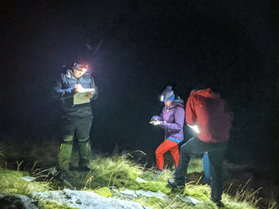
Packing a light bag, we went back out for a night expedition up Snowdon, heading up the south ridge, through the cloud levels, and reaching the top with clear skies. A great way to finish off the week! A couple of photos were taken and we returned along the Watkin Path to camp and were back in our sleeping bags for midnight.
Being used to multiple long days surveying for HARVEY Maps, and solo adventures at the weekend, I was confident of completing a day of training, followed by a night foray on to Snowdon. This for me was a highlight of the week's training.
Lewis undertook his Mountain Leader training in Snowdonia and he recommends taking a map with you whenever you head to the hills and mountains. His map of choice for Llanberis and Snowdon is the HARVEY Superwalker 1:25,000 scale map, Snowdonia North.
Return to the News & Features Blog


