FREE UK tracked delivery
 Order by 12pm Mon-Fri for same day dispatch
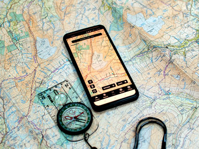
Map and compass, or phone? Integrating your devices
by Nigel Williams
For those of us old enough to have been brought up using a map and compass we can enjoy the benefits of using both, largely with the phone as the backup or to expand the map as our eyesight isn't what it used to be. For teenagers navigating in the outdoors - Scouts, DofE, cadets etc, purchasing good quality mapping, digital or paper, for the countryside is potentially a barrier. They have been brought up using the basic free mapping, such as Google Maps, which lacks the detail needed for the hills and they have learnt to use that mapping through personal experience or peer sharing of knowledge rather than a structured teaching of navigation skills. More often than not they have also endured classroom-based map reading instruction and decided it is too difficult. When it comes to carrying out an expedition, their leaders usually issue them with an A4 paper map sheet.
It probably seems logical to them to continue to navigate with the phone when in the countryside. It is only through outdoor experience that they become aware of well known weather related issues - such as battery life, cold temperatures, bright sunlight, touch screens and rain. My personal view is that the impact of habitual use on our cognitive development is the most serious issue. It bypasses observation of our surroundings and navigation decision making in our early years which research suggests will have a lifelong impact.
Tips on combining your paper map and your phone
So, here are some navigation skills combining the phone with a paper map which may help entice younger generations to appreciate paper maps whilst using their everyday technology and also provide a backup.
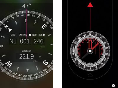
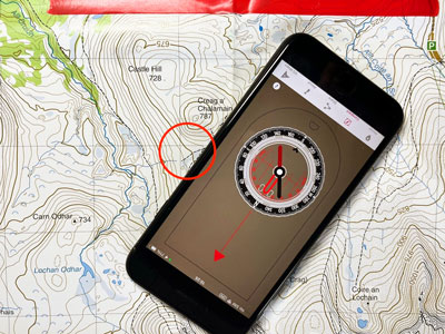
In the middle is a grid reference and an altitude and a + /- accuracy reading. On a paper map you can pin point your location with the grid reference - best to keep to a 6 figure
reference accurate to within 100m.
Less accurate but still useful is an altitude reading. On an iphone this is generally accurate to 10-20m (2 contour lines). Android phones are consistently about 50m out. This feature is particularly useful if one is on a well-marked path or other linear feature ascending or descending a hillside or ridge. Read off the height and find the nearest contour numbers on the map, from that you can find where the corresponding contour line crosses your path that will pin point your position reasonably accurately. It also gives one an idea of height gained or lost and how much more is to be done.
Moving onto the app's 'compass', you can use the phone as a compass on your map the same way as you would a normal base plate compass. The dial can be turned with two fingers to set a bearing. But it is easier to ignore this by keeping the compass in position on the map rather than separating it from the map. This actually makes things easier particularly if trying to operate the screen in difficult weather conditions. The only two relevant bits of the compass are the edge of the phone and the moving red needle.
Imagine being at a multi path junction and just needing to be sure which path you need to take. Orientating the map may provide the answer - however, a more accurate method is to simply put either of the long edges of the phone along the planned path on the map and keeping the phone tightly in place on the map turn them as a single item until the red needle points to the top (north edge) of the map and aligns accurately with the N/S grid lines. The thin red arrow down the base plate on the screen will be pointing down the path you want. This is a quick decision-making use of the device. The same technique can be used with a normal compass.
Interestingly, within the information menu it does not explain much of this and offers how to take a bearing with a compass (rather than the phone) for going across country which most people, and certainly beginner walkers and navigators, should aim to avoid. Walking cross country on a bearing requires a range of additional skills.
The phone compass can do everything a normal compass can do, however, for many of the reasons given earlier it would also be good to have a normal compass in your bag so the devices can back each other up.
Top tip - Remember to keep phones and compasses well apart to avoid the magnet in the phone speaker interfering with the magnetic compass needle!
- If you are in need of a compass then we stock a great range of items and other useful navigation equipment, suitable for all levels of navigation.
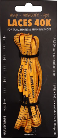
- For the perfect lanyard to go with your compass, the HARVEY Map - Measure - Go! scale bar laces double up to make measuring distance easy! Available in two scales, 1:25,000 scale markings (red) and 1:40,000 scale markings (yellow).
Return to the Navigation Blog