FREE UK tracked delivery
 Order by 12pm Mon-Fri for same day dispatch
May 2021 - Beginner's Guide to Navigation - Contours
by Nigel Williams
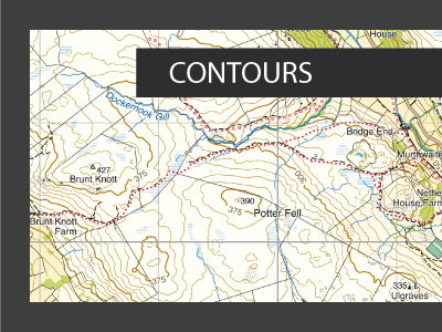
Each contour line runs across a slope keeping at exactly the same height above sea level. They are usually in 5, 10 or 15 metre intervals above sea level. Every 5th one is thicker and known as an index contour so they are at 25, 50 or 75metre intervals depending on the mapping.
The closer the contour lines the steeper the slope and the further apart, the gentler the slope.
A single isolated small circle depicting a tiny hill would usually be described as a knoll. The gap between two adjacent hills is known as a Col, a Saddle or a Pass, often marked on maps of Scotland as a Bealach or a Bwlch in Wales. When standing at a Col the ground should be flat but rising on two sides and dropping away on the other two (rather like a saddle shape).
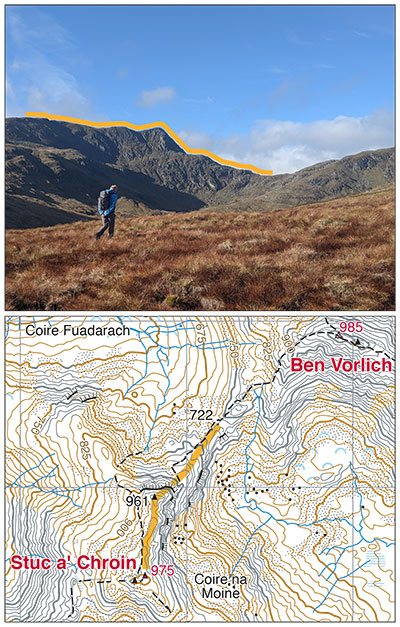
V or U shaped contour lines pointing downhill away from a hill top indicate a spur - a finger of higher ground sticking out into lower ground. If the V is pointing uphill this is indicating a valley. There may well be a stream shown in it. Small indents in a contour line illustrating a mini valley are referred to as "re-entrants". Contour height numbers can also be useful in working out which way the V is running.
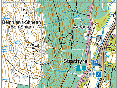
A way to illustrate Vs is to place your hand with your fingers spread out on a sheet of paper and draw around your hand and fingers, then add some circles representing hill tops to the diagram where your knuckles were. Your fingers are spurs, high ground coming from your knuckles and between them are valleys.
When following a path on the map, note its direction in relation to the contours. If it crosses contour lines at right angles, then on the ground you should see and feel that you are going straight up or down. Crossing the slope diagonally left or right or up or down should also be apparent. If the path runs along a contour line then the path will feel flat and the walking easy. A path I know climbs gently for nearly 3km around the side of a hill. There is one place for about 300m where it is flat and that is the only place in 3km where the path is marked on the map as running parallel to the contour line. I can immediately feel and see where I am on the map.
Lastly, "slope aspect". This is a simple concept more relevant to hill navigation. Imagine a huge ball bearing running away down the slope - it would be travelling across the contour lines at right angles. Using just the compass needle estimate that direction of travel. It indicates which way the slope faces. Why is this useful? Well, it is easy to take the wrong path off the top of a hill in poor weather. Checking the slope aspect will reveal the error, finding yourself on a west facing slope when you had intended descending the east side of the hill. Or if completely disorientated for instance working out you are on a west facing slope means you can probably eliminate ¾ of the map where you cannot be - on an east, south or north facing slopes. It is negative information but so valuable if misplaced in the hills and essential in winter.
Return to the Navigation Blog