 FREE UK tracked delivery
 Order by 12pm Mon-Fri for same day dispatch
November 2018 - Altimeters
by Nigel Williams
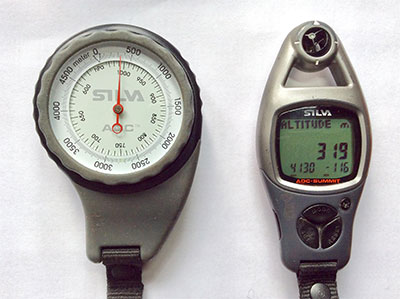
There are two types of altimeter. The traditional barometric altimeter which measures air pressure, and the GPS satellite based system. Some GPS devices have both systems. GPS readings can be inaccurate close under cliffs or on steep ground. Barometric altimeters can be inaccurate on ridges and cols where the wind creates a vortex or is funneled, creating pockets of low and high pressure. Both rely on battery power for a digital reading, although traditional barometric altimeters are analogue.
The higher we go the less the air pressure. This is how the barometric altimeter works. However, the device needs to be calibrated at regular intervals.
A synoptic weather chart uses isobar lines similar to contours. These are lines of equal pressure. A typical Low pressure series of concentric circles crossing the Atlantic and passing over the UK travels at about 25mph regardless of the wind speed. Those lines would pass overhead if we stayed in the same place on the ground. As the centre of the Low comes towards us the pressure decreases giving a higher altitude reading. As the centre of the Low moves away the pressure rises giving a lower reading. 3 Isobars passing over will change an altitude reading by about 100m. Therefore a manual adjustment is required every 30 or so minutes at known heights on the map. The car park, path junction, hill top etc. It also means that they are not super accurate but will be within 10 metres or so.
On multi day journeys barometric altimeters provide a weather forecasting tool. When waking in the morning, if you find that the altimeter suggests you have slid downhill 100m you know the weather is improving - high pressure is developing. If you have been elevated then low pressure, probably poor weather is on the way.
Return to the Navigation Blog


