November 2019 - Contours the 3rd Dimension
by Nigel Williams

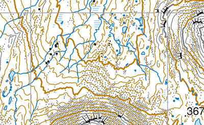
When we walk with a map we look to see what is around us and then look for it on the map or vice versa. Interpreting contours into something meaningful can seem a challenge but with a little practice it all starts to make sense. Contours are conceptual really and I think we often start with too big a landscape when teaching the subject. Class room models and orienteering scale maps with small hills, cols, spurs and valleys with varied contour spacing enable a better grasp of what they are all about. Look closely at the contour lines on the map - their spacing and therefore steepness of the ground is constantly changing.
There are little v shape bits, small spurs and gullies (often referred to re-entrants), sometimes just involving one or two contour lines. Streams and other features give us the clue as to which is a spur and which is a re-entrant. A circular contour line would indicates the top of a hill. These are sometimes referred to as the rule of Vs and Os.
The contour height numbers are of course a valuable clue as to what is up and down. If you are reading the numbers the right way up on the map you are effectively looking up the hill.
Unique to map information, contours provide a sensory experience as well as a visual one. You can feel ground shape and your relationship to it under your feet. It impacts ankle and leg joints, muscles (and even lungs). It affects our balance and we compensate for it. If we study the contours on our path the changes become tick off features or catching features as we go, eg the steepness of the ground is easing off. Instead of just knowing we are on the path we can identify where we are on it. The same principal works if we are walking on a bearing with a compass in poor visibility or at night.
Other sensory information helping us keep track of our direction of travel comes from things like changes to the feeling of the wind on our face, changing where the sun is in relation to our direction of travel, hearing running water - must be near a stream etc.
Return to the Navigation Blog
 FREE UK tracked delivery
 Order by 12pm Mon-Fri for same day dispatch


