FREE UK tracked delivery
 Order by 12pm Mon-Fri for same day dispatch
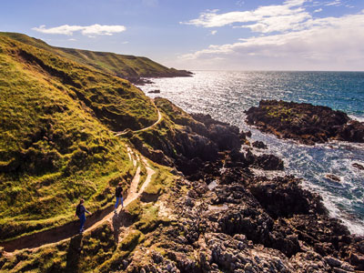
The Wales Coast Path
As all 4 maps are now available and being used by so many of you already, we spoke with Eve Nicholson, Wales Coast Path Marketing, to find out more about this coastal long distance path, and the role Natural Resources Wales play in managing the path.
All images © Crown Copyright
Wandering around Wales
Wales is a small country with a big heart in the west of the UK. You can enjoy the diverse landscape of mountains, coast and sea within a short distance of each other. It is something special to experience.
In Wales, you can try some adrenaline-filled activities like coasteering and gorge walking. The purpose-built adventure attractions of inland surfing and the longest zip wire in Europe (that's Zip World in north Wales by the way) may also whet your appetite for adventure.
But to experience the sheer natural beauty of Wales (Cymru in Welsh) for more than a few adrenaline-filled moments, we recommend a more relaxed pace.
The Wales Coast Path (Llwybr Arfordir Cymru in Welsh) is one of a few footpaths in the world to follow a country's entire coastline, measuring 870 miles / 1,400 km long. The idea was to join up existing coastal paths like Anglesey Coastal Path, Llyn Peninsula, Ceredigion and Pembrokeshire.
The path opened in May 2012 with accolades from the Rough Guides and Lonely Planet. In 2022, the path's 10th anniversary year, the National Geographic highlighted the diversity of the path to its readers.
The end/start points are in Flintshire on the border with England, just outside Chester in the north and Chepstow in the south. New Quay / Cei Newydd is a popular seaside town, which marks the official half-way point of the path. You'll see a beautiful sculpture who wishes travellers well on their onward journey.
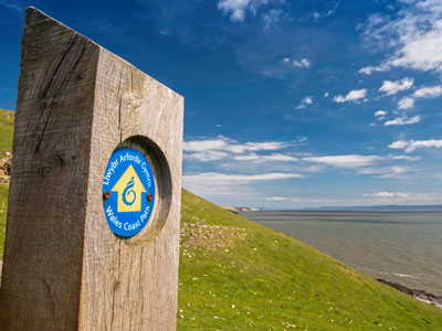
The entire path is signposted with our distinctive blue and yellow signs. We recommend carrying a map with you as well. Look out for the dragon shell logo - it will be your beacon along the way.
Who manages the path
Natural Resources Wales (NRW) coordinates the development, maintenance, and the marketing of the path. As the largest Welsh Government Sponsored body in Wales, we work with key partners like Welsh Government (who fund the path), working with 16 local authorities and 2 national parks.
The local authorities maintain the path and negotiate access with landowners to make sure there is a continuous coastal footpath. The WCP will join up with the England Coast Path when it's ready.
I work with my colleague Sioned on the marketing aspect of the path. We're a small team but have lots of connections. We collaborate with a wide variety of partners to encourage people to enjoy the path's diversity and explore the working Welsh coastline where industry, urban and rural lives co-exist. We work with a wide variety of partners like Visit Wales, Ramblers Cymru and Muslim Hikers and many others.
The most asked question I get about my job is "have you walked any of the path?" The sad but rather optimistic answer is "not a lot, but I'm getting there". Our walk and talk meetings (on the path of course!) enrich our own understanding of a visitor's perspective - practice what you preach is what we say!
Our collaborative approach is a balancing act of promoting the path as a key Welsh visitor destination, whilst respecting the biodiversity, Welsh culture and the Welsh language.
Along the path, you'll have lots of opportunity to see and hear Welsh - an official language of Wales. You'll see a lots of signs with morfa (coastal marsh), aber (mouth e.g mouth of an estuary), ynys (island), traeth (beach) to name but a few.
Where are the best bits of the path?
Beauty is in the eye of the beholder!
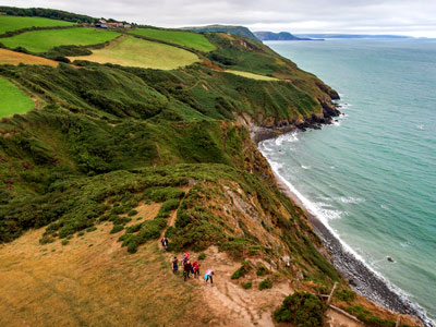
The most popular sections of the path are the Isle of Anglesey, the Llyn Peninsula, Ceredigion and Pembrokeshire. They offer superb coastal vistas, panoramic views, and lots of leg work outs with the ups and downs of the path. But some people enjoy the twinkling of the industrial sections at dusk, whilst others enjoy the flatter sections and cool shaded woodland - ideal for a spot of wildlife watching.
Either way, the path has something to offer everyone.
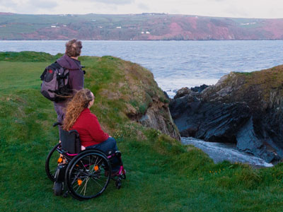
Our vision is that the path is open and inclusive to everyone, now and for future generations. We work by the principle of least restrictive access where possible, like removing unnecessary barriers and improving the path surface. This can make all the difference to people with mobility needs.
We aim to provide descriptive information path information where possible, like gradient, width and any barriers and not give ratings of difficulty, because it's subjective.
The natural terrain of a coastal path means that it's not open to everyone. There are sections where you can cycle the path using the National Cycle Network. For example, route number 5 along the majority of the north Wales coast section.
We have a list of sections of the path where you can go with a wheelchair to get close to the coast as possible e.g near Mwnt in Ceredigion - a popular section of the path overlooking Cardigan Bay.
To sum up 870 miles
The Wales Coast Path offers a myriad of experiences, some say life changing ones. Ambling your way along the path can offer a different perspective on life.
And if you're a dedicated soul who relishes a challenge, imagine your sense of achievement of having walked the coastline of an entire country. Now there's something to talk about with your friends, family and any future grandchildren.
Further information
- Visit www.walescoastpath.gov.uk for an interactive map, distance tables and over 100 walking itineraries.
- Follow @walescoastpath for news and updates on social media Facebook, Twitter and Instagram.
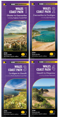
If you're feeling inspired to take on the varied splendour of the Welsh coastline this summer, check out the set of 4 HARVEY Maps to help you along the way. Printed on 100% waterproof paper at 1:40,000 scale, all 4 maps weigh only 210g in total - making them the perfect addition to your long distance walking pack!
Return to the News & Features Blog